Unified Reality Capture and Remote Sensing Explained
In an increasingly digital world, the ability to accurately represent and interact with our physical environment is paramount. Two closely related technologies, reality capture and remote sensing, are at the forefront of this transformation. While often used interchangeably, they represent distinct but complementary approaches to gathering information about the world around us. This article will delve into the nuances of each, exploring their methodologies, applications, and the profound impact they are having across various industries.
What is Reality Capture?
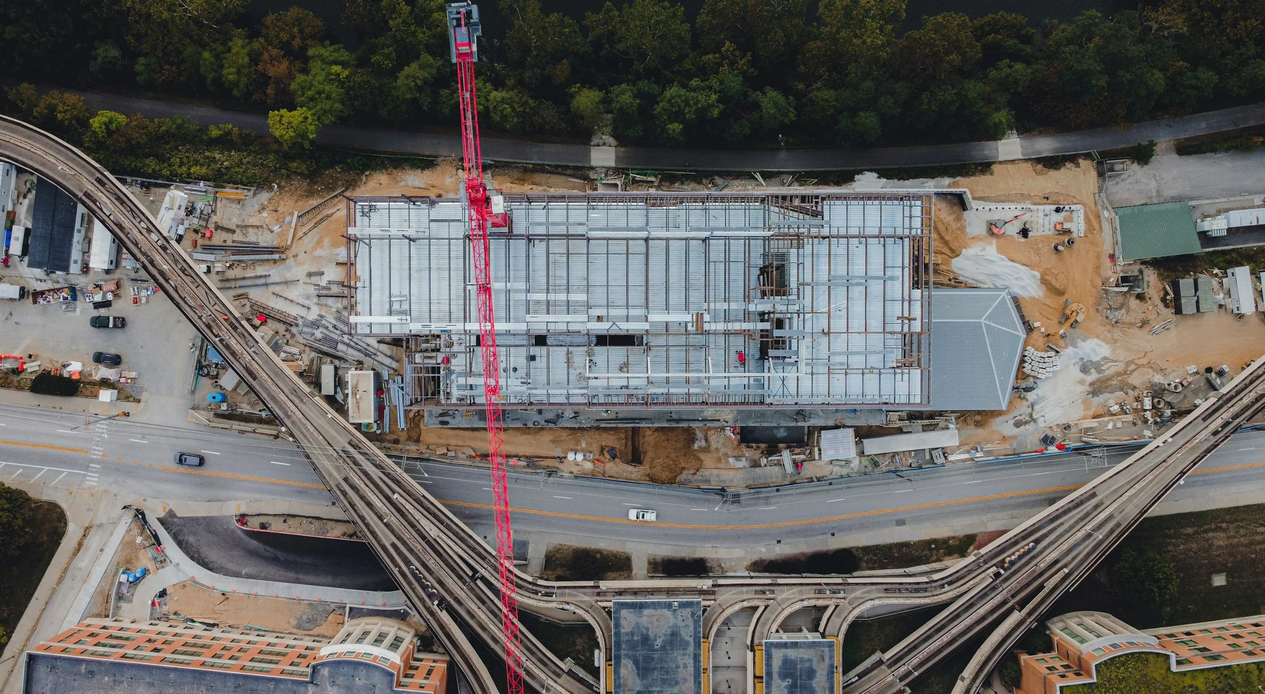
Reality capture, at its core, is the process of collecting data from the real world to create a digital model or representation. Think of it as digitizing physical objects, spaces, or even entire environments. This process typically involves capturing millions of individual data points, often in three dimensions, to create a highly accurate and detailed replica. The resulting digital model can then be analyzed, manipulated, and utilized for a wide range of purposes.
Check out our related article: “Precision Reality Capture: Revolutionizing Construction”.
Methodologies of Reality Capture
Several technologies contribute to the broad field of reality capture, each offering unique strengths:
3D Laser Scanning (LiDAR): This is perhaps the most prominent reality capture technique. LiDAR (Light Detection and Ranging) systems emit pulsed laser beams and measure the time it takes for these beams to return after hitting a surface. By calculating these time differences, a highly precise 3D "point cloud" is generated, representing the geometry of the scanned object or environment. Terrestrial laser scanners are commonly used for buildings, industrial facilities, and archaeological sites, while mobile LiDAR systems mounted on vehicles or drones can rapidly capture large areas.
Photogrammetry: This technique involves taking multiple overlapping photographs of an object or scene from different angles. Specialized software then uses algorithms to identify common points in these images and reconstruct a 3D model. Photogrammetry is often more cost-effective than laser scanning for certain applications and can produce highly detailed textured models, making it ideal for visual representations. Drones equipped with high-resolution cameras are increasingly used for photogrammetric surveys of landscapes, construction sites, and historical structures.
Structured Light Scanning: This method projects a known light pattern (like grids or stripes) onto an object and then uses a camera to capture the deformation of that pattern. The distortion reveals the object's 3D shape. Structured light scanners are particularly effective for capturing intricate details of smaller objects and are often used in manufacturing, quality control, and reverse engineering.
Mobile Mapping Systems: These integrated systems combine LiDAR, cameras, GPS, and Inertial Measurement Units (IMUs) on a moving platform (vehicle, backpack, or drone) to rapidly capture extensive datasets of roads, infrastructure, and urban environments. They are highly efficient for large-scale surveys and can collect both 3D spatial data and high-resolution imagery simultaneously.
Applications of Reality Capture
The applications of reality capture are vast and continually expanding:
Architecture, Engineering, and Construction (AEC): Reality capture is revolutionizing the AEC industry by providing accurate "as-built" documentation, enabling better planning, design validation, and progress monitoring. It facilitates Building Information Modeling (BIM) by providing precise existing conditions data.
Cultural Heritage and Preservation: 3D models of historical sites, artifacts, and artworks are created for documentation, conservation, restoration planning, and virtual tourism. This allows for detailed study and public access without risking damage to the original objects.
Manufacturing and Quality Control: In manufacturing, reality capture is used for reverse engineering existing parts, verifying product dimensions against design specifications, and identifying defects.
Forensics and Accident Reconstruction: Precise 3D scans of crime scenes or accident sites provide invaluable evidence for investigations and reconstructions, allowing for detailed analysis and presentation.
Filmmaking and Gaming: Reality capture is used to create highly realistic digital assets for visual effects, virtual environments, and video game development, significantly enhancing immersion.
What is Remote Sensing?
Remote sensing, in contrast to reality capture's focus on close-range, highly detailed spatial data, involves collecting information about an object or area from a distance without physical contact. It primarily relies on detecting and measuring emitted or reflected electromagnetic radiation. While reality capture often provides geometric accuracy, remote sensing excels at providing spectral information, covering vast geographical areas, and monitoring changes over time.

Methodologies of Remote Sensing
Remote sensing utilizes a variety of platforms and sensors:
Satellite Remote Sensing: Satellites equipped with various sensors orbit the Earth, continuously collecting data across broad regions. This is the most common form of remote sensing and provides a global perspective. Examples include:
Optical Sensors: Capture visible, near-infrared, and shortwave infrared light reflected from the Earth's surface. Used for land cover classification, vegetation monitoring, urban mapping, and disaster assessment.
Thermal Infrared Sensors: Detect heat emitted from surfaces, useful for monitoring temperature changes, volcanic activity, and urban heat islands.
Radar (Synthetic Aperture Radar - SAR): Emits microwave radiation and measures the backscattered signal. SAR can penetrate clouds and operate day or night, making it invaluable for observing areas frequently covered by clouds, such as tropical rainforests, or for monitoring ground deformation.
Aerial Remote Sensing: Aircraft (manned or unmanned drones) carry sensors similar to those on satellites but operate at lower altitudes, allowing for higher spatial resolution and more flexible data acquisition. This is often used for detailed mapping, environmental surveys, and urban planning.
Hyperspectral and Multispectral Imaging: These advanced optical techniques capture data across a large number of very narrow spectral bands (hyperspectral) or a few broad bands (multispectral). This allows for highly detailed analysis of material composition and properties, often used in agriculture, geology, and environmental monitoring.
Applications of Remote Sensing
Remote sensing has a profound impact on our understanding of the Earth and its systems:
Environmental Monitoring and Climate Change: Tracking deforestation, glacier melt, sea-level rise, ocean temperatures, air pollution, and changes in land use patterns.
Agriculture: Monitoring crop health, predicting yields, detecting plant stress, and optimizing irrigation and fertilization.
Disaster Management: Assessing damage after natural disasters (floods, earthquakes, wildfires), supporting search and rescue operations, and planning recovery efforts.
Urban Planning and Development: Mapping urban sprawl, analyzing population density, and managing infrastructure.
Geology and Resource Exploration: Identifying mineral deposits, mapping geological structures, and monitoring volcanic activity.
Oceanography: Monitoring ocean currents, sea surface temperatures, and marine ecosystems.
The Synergy: Reality Capture and Remote Sensing
While distinct, reality capture and remote sensing are increasingly converging and complementing each other. For instance:
Drone-based systems blur the lines, as they can perform both detailed 3D photogrammetry (reality capture) of a specific site and broader spectral analysis (remote sensing) of vegetation health in the surrounding area.
Large-scale urban modeling can leverage both satellite imagery (remote sensing) for broad context and aerial LiDAR (reality capture) for detailed building geometries.
Environmental monitoring might use remote sensing for wide-area change detection, then deploy reality capture techniques to create detailed 3D models of specific affected areas for in-depth analysis.
Conclusion
Reality capture and remote sensing are powerful technologies that provide unprecedented insights into our physical world. Reality capture delivers highly precise, often 3D, digital replicas of objects and environments, ideal for detailed analysis, design, and visualization. Remote sensing offers a broader, often spectral, perspective, enabling large-scale monitoring, change detection, and understanding of Earth systems. As technology continues to advance, the integration of these two fields promises even more comprehensive and actionable data, driving innovation across countless sectors and helping us better understand, manage, and interact with our planet.