
CAMPING WORLD LOCATION INTELLIGENCE
Program Overview & Sample Store Package (DEMO)
Pilot Program Overview
This demo presents a standardized Store Digital Documentation Package that combines 360° ground navigation and aerial site overview into a repeatable, location-to-location format.
The same package supports customer planning (clear wayfinding and expectations before arrival) and operational execution (Facilities/Ops/Vendors alignment for scoping, coordination, verification, and recordkeeping), creating a single visual baseline that minimizes re-explaining and prevents drift in how sites are understood.
What This Enables
Customer-facing Value
“Walk the lot” before arriving (boosts confidence and aids wayfinding)
Internal Operations Value
Remote project planning and vendor coordination efforts
Faster scoping and quoting support with a consistent visual context for clearer decision-making
Repeatable documentation for consistent before-and-after comparisons
Pilot Program Structure
Data Collection Tiers I–III

Tier I
Terrestrial 360 walkthroughs (Customer + Ops/Facilities paths) with labeled POIs, plus an aerial overview still set.
(standard for every location)
Walkthrough + Ops Baseline

Tier II
A measurable orthomosaic map for planning, measurement, and vendor coordination. (Pilot note: delivered on three locations to validate mapping value without increasing pilot cost across the full set.)
(applied selectively)
Facilities-Grade Map

Selective 3D
Tier III
Exterior 3D model/point cloud for specific needs (storm documentation, remodel candidates, high-value locations, etc.).
(case-by-case)
*Tier 1 supports Ops and customer planning; Tier 2 supports Facilities/CapEx workflows; Tier 3 is reserved for locations that warrant higher detail.
Demo Links
-
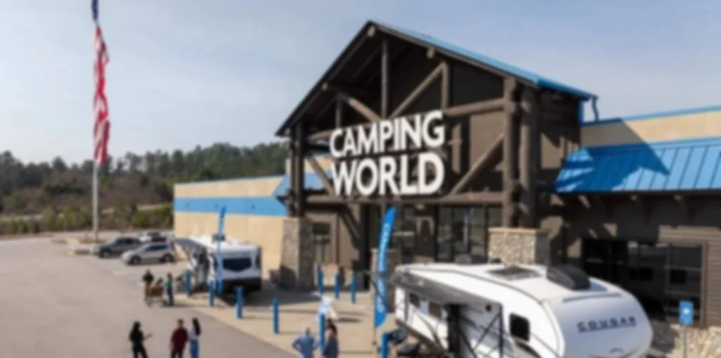
Customer Facing Views
360º Walkthrough (Tier 1)
Includes: Main approach, primary customer circulation, key decision points
POIs: Main entrance, service intake, parts pickup, RV delivery lane, overflow parking
-
Ops / Facilities Views
360º Walkthrough (Tier 1)
Includes: Service lane + perimeter loop + asset zones + back of house
Tags: Lighting, signage, pavement, drainage, fence line, roofline/exterior, wayfinding
-
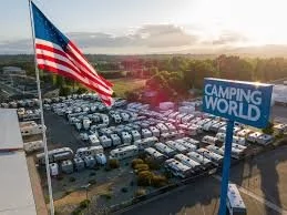
Aerial Site Overview
Site Context (Tier 1)
Purpose: fast site comprehension, access planning, coordination context
Contents: Nadir + oblique angles; “explain-the-site-in-10-seconds” views
-
Facilities Maps
Orthomosaic Maps (Tier 2)
Purpose: planning + measurement + “what’s where” clarity
Notes: Intended for Facilities / CapEx / vendor coordination workflows
-
Exterior 3D Model
Aerial Digital Twin (Tier 3)
Purpose: remodel candidates, storm-hit documentation, high-detail review
Scope: Selected area only (pilot would apply Tier 3 selectively)
Access & Hosting (Pilot)
Demo links open in ProAerial Media’s DroneDeploy workspace (view-only) for pilot hosting and fast review. All deliverables are also available as export packages.
Should the program scale, data can be migrated into a Camping World–owned DroneDeploy tenant (or preferred platform) for long-term governance.
Pilot Program Specifics & Success Metrics
Location: Florida (10–15 sites)
Duration: 3 weeks (phased delivery in batches)

-
Give vendors and internal teams consistent visual context — including approach, access lanes, service intake, and staging — so scoping can be done remotely and completed more quickly.
-
Standardized before-and-after records for perimeter, signage, lighting, pavement, and drainage—neatly organized by site and easily retrievable on demand for rapid review.
-
POI-labeled walkthroughs reduce internal back-and-forth by clearly marking service intake, parts pickup, delivery lanes, and access paths, making workflows more efficient and minimizing confusion.
-
Customer-path 360º views help visitors plan their arrival and confidently navigate the property—especially valuable for first-time customers seeking clear orientation and reassurance.
What “Standardized” Means
Each location is delivered with the same:
Capture Spec (coverage, spacing, angles, QC requirements)
File Structure + Naming Conventions
POI and Tag Vocabulary (consistent labels across all locations)
Deliverable Package Layout (so anyone can open and understand it quickly)
This standardization enables national rollout and year-over-year repeat capture.
SCHEDULE 20-MINUTE PILOT PROGRAM QUALIFICATION CALL
*This is a ProAerial Media demo and is not affiliated with or endorsed by Camping World.