How To Sell Rural Vacant Land with Aerial Photos & Video
Residential and commercial Realtors, real estate companies, and property management businesses, all leverage aerial photography and video in their real estate listings. But what about using aerial photos and video for rural vacant land sales?
In this article, we’ll be showing some of the services a commercial UAV pilot or aerial photographer can provide to realtors and those selling undeveloped land.
This writer assumes that we agree on a few basics before we begin. They are; first, an aerial view is further reaching than one from land. Second, aerial images are simply cooler or more compelling to look at. And third, real estate and property listings with aerial photographs get more clicks and views than listings without.
With that said, let’s take a look at some of the types of aerial images and media that can be produced specifically for marketing and selling rural vacant land.
Standard Aerial Photography for Rural Land Marketing
From a usage standpoint, simply adding aerial photography of your rural property will help it stand out amongst the many options a potential buyer will be bombarded with.
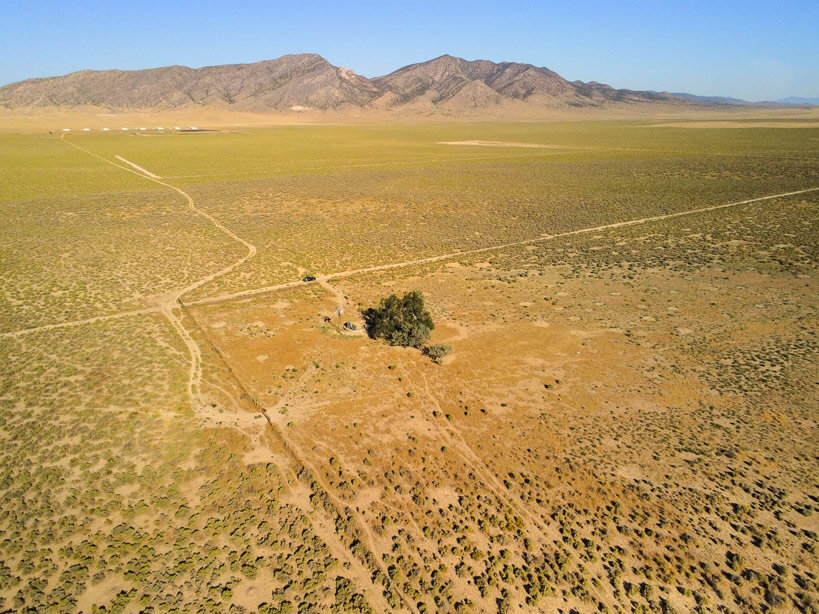
Aside from photographs of the property itself, consider showcasing views from the property that can provide a frame of reference to the viewer. These images can be edited during post-processing to highlight distant points of interest, road and waterways, and property boundaries. You could even use drone photography to compare data from historic aerials found in public records.
View our Rural Land Real Estate Image Gallery
Aerial Panoramic Images for Rural Land Marketing
Probably one of the greatest features of most drones is their ability to capture panoramic images from perspectives that would be otherwise impossible.
180-degree Panorama (Click to enlarge)
360-degree Panorama (Click to enlarge)
Most panoramic images afford the viewer a 180-degree view of the subject, though certain models like the Parrot Anafi are capable of capturing a full 360-degree image. You should be able to immediately see the difference between the two types in the below examples, as certain elements near the bottom of the 360-degree image become distorted.
View our Panoramic Image Gallery
Aerial Videography for Rural Land Marketing
It goes without saying that video can be more impactful than still images, and as such aerial video is even more so. Many of the same shooting techniques used to market and sell developed real estate can be used to market and sell undeveloped and rural land as well.
Here’s a list of some of the classic aerial video shots needed for almost any property:
The Orbit - This is typically flown autonomously and is the epitome of aerial video, creating a continuous loop around the property with a fixed horizon.
The Rise and Reverse Away - Start with a closeup of the area of interest, then slowly reverse away and increase altitude.
The Cable Slide Pan - A difficult shot to pull off, but worth it. Flying the UAV along a straight line parallel to the area of interest, pan the camera keeping it fixed on a specific point as you do so.
The Upward Reveal - Start the shot low with a focus on the property, slowly begin to increase altitude while gently panning down.
The Descent - This is basically the opposite of the Reverse & Fly Away
The Overhead - The simplest to pull off, and usually the most impressive. Point the camera straight down, and begin to increase altitude. For an even more impressive shot, slowly rotate the drone (yaw) as you gain altitude.
For properties located ‘off the beaten path’, we recommend producing what we call a “Drive Video”. These videos are produced using an array of equipment including drones, terrestrial cameras, GoPros, and even iPhone footage. Compiled together into a storyline that takes the potential buyer along on the trip to the property, highlighting key features and facts along the way.
Client: Mike’s Lands LLC
Project: 100-acre parcel in Iron County UT
Drone Mapping & Surveying
For parcels where future development and landscaping are considerations, consider a drone mapping mission. Here, the technical details of the terrain like elevation changes and grade can be obtained using drone mapping or aerial photogrammetry.

DSM (Digital Surface Model)
Photogrammetry, simply put, is the science of making measurements from images. This process involves computer software and produces what is called a “Point Cloud” and 3D Model of an area. We can then export other various image files like Orthomosaic Maps, Digital Surface Models or DSMs, Digital Terrain Models or DTMs, Topographic Maps, and even AutoCAD ready files.

3D-Model
This process involves flying the drone along a predetermined route at a fixed altitude while capturing dozens if not hundreds of images of a piece of land or area of interest. Once complete, images are processed in specialized photogrammetry software (we prefer Pix4D) allowing for some very sophisticated outputs. Imagine a single map layer image of a 100-acre parcel of land that was accurate to within a few centimeters. These ‘ortho-maps’ have no distortion near the edges and enable you to make highly accurate distance and volumetric measurements.
Get A FREE Mapping Quote
If you’d like to learn more about our mapping services, check out these our articles “What Is Photogrammetry? Answered in Under 100 Words” and “What Is Drone Mapping Used For? Overview + Use-Cases”.
The long and short of it is this; if you’re not utilizing aerial photography to sell your rural vacant land, you’re going to get left behind. We recommend seeking out and partnering with a local Part 107 Commercial UAV Pilot in your area. Sites like Droners.io can help you find licensed pilots across the United States, read reviews, and view their work. If you want the land your selling to be seen, be sure to include aerial photos and video with the listing’s digital imagery. The better you understand what you’re buying, the better you’ll be able to communicate what you want to your pilot/photographer, yielding better results.
ProAerial Media provides all of the aerial drone services listed above as well as for special events like weddings. Subscribe to our YouTube Channel to see our video work, and our Instagram feed to view our photography (@proaerialmedia). If you’re ready to fly, you can always book a flight from the ProAerial Media Website.
Thanks for reading. Take Flight. Take Pics. Get Clicks.